|
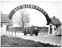
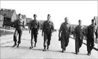
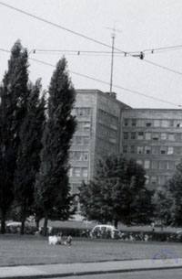
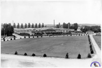
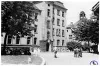
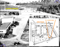
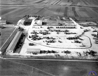
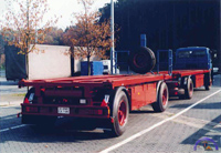
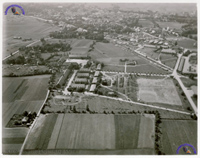
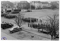
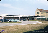
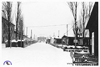
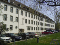
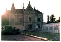
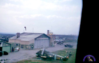
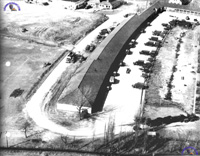
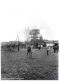
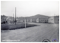
Photo #1
Source: 18th FA Group Yearbook 1957
Known Information: photo is from 1957 or before; jeep leaving the installation has tactical markings of the 3rd FA Rkt Btry (7A 3F -- X 8); gate is identified as Gate #2.
Question: Which kaserne or training area are we looking at?
Response: (1) This is just speculation: the photo might have been taken at Grafenwoehr Training Area's Gate #2, which lies in the German community of "Tanzfleck". Today, as far as I know, Gate #2 still is located at Tanzfleck, south gate of GTA. (Oliver Geyer)
(2) The unknown picture number 1 is Gate 2 in Vilseck (Südlager) and it used to be the exit of the Grafenwöhr Training Area to Vilseck and Sorghof. Now it is the main gate of the "Südlager" and looks totally different. The gate at Tanzfleck is and has always been Gate 4.
Best wishes,
Frank Hummel (Germany)
|
|
|
|
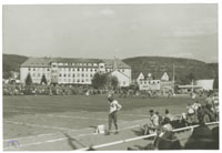
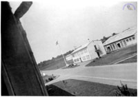
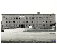
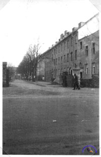
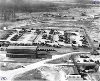
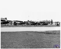
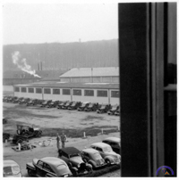
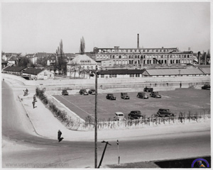
Photo #2
Source: Author's collection
Known Information: photo is from 1950's; location is most likely the football field at Coleman Kaserne, Gelnhausen; the Home team, the Warriors, are behind 0-13...
Question: Who are the "Warriors" (a unit team probably) and can anybody identify the year that the photo was taken?
Responses: (1) The 12th Infantry Regiment, with home station in Gelnhausen, in the early 1950s, were known as the "Warriors." So, the photo was taken sometime between 1951 and 1956 when the 4th left Europe and was replaced by the 3rd Armd Div.
(2) Your mystery pic of Coleman Kaserne at Gelnhausen Germany was probably taken either before 1953 or after 1956. My building was the one directly behind the post chapel. I do not recall there ever being a football game in the 35 months that I was stationed there and I don't remember the score board either. One of Mr. Thompson's pix of the post taken in May 1950 shows the football field as being close to the south perimeter fence (you can see the goal posts in the picture) and that area was the truck park and well graveled when I arrived there in the summer of 1953.
Thanks for all your hard work on a really nice site. (Harold Varney)
|
|
|
|
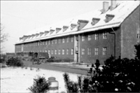
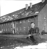
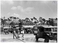
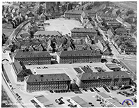
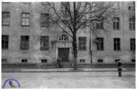
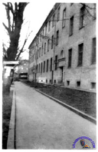
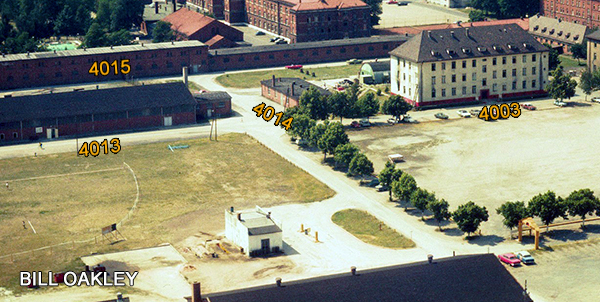
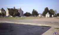
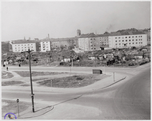
Photos #3A, 3B & #3C
Source: Terry Burroughs, son of a veteran of Battery B, 580th AAA AW Bn
Known Information: photos were at a kaserne in Munich that was occupied by US troops in 1945 soon after the end of WWII; unit stationed there at that time was Battery B, 580th AAA AW Bn; this same kaserne was also used by Battery B, 398th AAA Battalion which operated PX Depot #198 from a large warehouse type building there; the soldiers knew the installation only as Saarkaserne and there was an airfield nearby; also, the kaseren was "generically" referred to as "SS Barracks" .
Question: Who can identify the kaserne and, possibly, provide more details?
Responses: (1) Photos # 3A, # 3B, and # 3C are at Panzer Kaserne (later renamed Will Kaserne) located on Ingolstadter Strasse directly east the SS Kaserne Freimann, in north Munich. The location of Panzer Kaserne is shown on the map on your website for installations in north Munich.
I am unable to find much historical information relative to the Panzer (Will) Kaserne. Would appreciate any historical information about Will Kaserne anyone could send, and desire a possible confirmation of these photos from anyone who served a postwar assignment at Will Kaserne.
Terry Burroughs
(2) I am a German officer in Munich and I just saw the pictures of unidentified Photos #3A, 3B & #3C.
They do show a Munich barracks that is named Fürst-Wrede-Kaserne today. It was built for a pre-war antitank unit of the German Wehrmacht, Panzerabwehrabteilung 7, and later named Verdun-Kaserne. The US Forces renamed it Will Barracks.
The barracks are in the far north of Munich next to the former SS-barracks of the Regiment "Standarte Deutschland", which was later part of the 2nd SS-Panzerdivision "Das Reich". This installation was called Warner Barracks by the US Forces and has the name Ernst-von-Bergmann-Kaserne today. It is now the medical academy of the German forces (Sanitätsakademie der Bundeswehr).
Next to the two barracks was a large training ground known as the "Panzerwiese". Maybe that is why US soldiers called the barracks "Panzerkaserne" as this was never its name...
Kai Reichardt
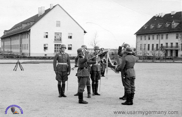
An oath ceremony of Panzerabwehrabteilung 7, 1938 in the Verdun-Kaserne (Kai Reichardt) |
|
|
|
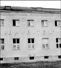
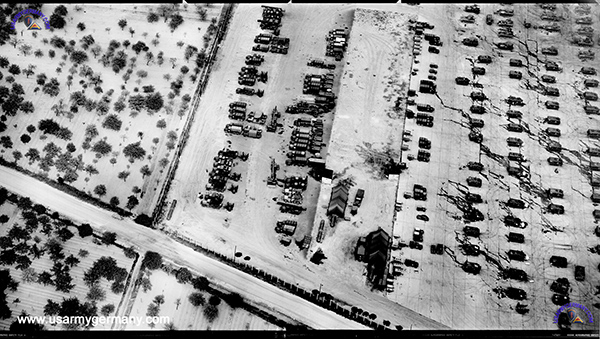
Photo #4
Source: Terry Burroughs, son of a veteran of Battery B, 580th AAA AW Bn
Known Information: photo is from late 1945; location is a former factory or industrial plant named "Bayritex" in Munich. Battery D 489th AAA Battalion was billeted in this building or complex in late 1945; it is believed that the complex was located somewhere on Tegernseerlandstrasse.
Question: Who can identify the complex and provide more details?
Responses: (1) The location of the BAYRITEX building in photo # 4, is presently suspected to be near or possibly within McGraw Kaserne in southeast Munich. There were some wartime industrial production operations at the McGraw Kaserne complex. BAYRITEX could be one of these.
I am thinking BAYRITEX is a logo for a Bavarian or Bayern textile products manufacturing facility. There were some German military units responsible for the development, production, and testing of military textile items and clothing. Perhaps BAYRITEX was such an operation and located within the McGraw Kaserne complex.
I remain inconclusive about the precise location of the BAYRITEX building in the photo, but now think it to be relative to McGraw Kaserne. I am certain BAYRITEX is located on Tergernseerland Strasse somewhere between Mariahilf Platz and McGraw Kaserne.
Terry Burroughs
(2) Due to historical research I came accross the US Army web page. Regarding your missing info page, I have seen the picture (#4) showing the BAYRITEX building. The Bayritex GmbH was a company purchasing/selling cloth/textiles for distribution to sewing companies for different reasons during the time of the 3rd Reich and were located all over Germany in major cities. In the last years of WWII it was replaced by the Reichszeugmeisterei (RZM).
The Munich RZM headquarters was located in today's Tegernseer Landstrasse 210 backyard to the St.-Quirin-Strasse (entrance same street) and used by the US Troops in Munich. The building still exists but there are rumors that something new will be built on that area. When I find the chance, I will take a current picture to submit to you. I hope I have supported you with my information.
Klaus Hinkelmann, München, Germany.
(3) I looked up the address of „Bayritex“ in the „Münchner Stadtadressbuch 1950“. This is the first post-WW II issue.
This is what I found:
Bayritex, Bayerischer Textil-Einkauf GmbH.
München 9, Tegernseer Landst. 142/144
F 40116
If mystery Photo #4 shows the building at Tegernseer Landstrasse 142/144, it was demolished and replaced by a apartment building.
Carsten Kattau, Germany
|
|
|
|
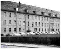
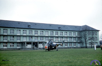
Photo #5
Source: photo album, unknown member of WOC, 97th Sig Bn
Known Information: comments written on back of the photo identify this building as the Headquarters Building for Seventh Army in 1954.
Question: Who can provide confirmation or details on which building this might be?
Response #1: That is Patch Barracks, yes. There were about five bldgs. the same. They were the G Sections: G-1,G-2, G-3, G-4. They looked much better in the early 1960`s.
All had basements for storage and snack bars (AYO), profits for little league and Pop Warner style football teams, for the dependent "brats."
All of us personnel were assigned as Clerks, paper pushers, were in Hq.Company.
Jack Dawes, US Army, Patch Barracks, Hq. Company, AG Printing Plant, 1963-1965 |
|
USEUCOM J-1 Bldg, 2007
|
Response #2: I was looking at your mystery photos and saw photo #5 and recognized the building, as I work next to it. Its now the US European Command J1 building. I've attached two photos taken of the building this past Friday (April 2007). Please let me know if you have any other photos of Patch back in the 1950s. We would like copies to put on display here at HQ, USEUCOM is possible.
LTC David S. Jones, US Army, J-2, USEUCOM, present
If anyone has pics that they think might be of interest, please contact the webmaster. I will be happy to forward all information/pictures to David. David mentioned in a subsequent email that
they (USEUCOM) will hold the Army Ball there on 9 June - this is a great chance to display stuff related to the US Army history in Europe. |
|
|
Image #6
Source: Author's collection
Known Information: identified as the crest for the USAREUR Communications Command Network.
Question: Who can provide confirmation or details on time period, organization of the unit(s) who wore this crest?
Responses: The crest shown here is a STRATCOM-EUR unit crest - "USAREUR Communications Command Net," worn in the 1960s-1970s time frame.
Keep up the excellent work on this site
Roberta Sanders |
|
|
|
Photo #7
Source: author's collection
Known Information: from comments written on back of the photo, this is a photo taken of the IG Farben Building in 1951
Question: Who can provide information on the antenna visible on the roof of the Farben Building? What type of communications is it used for and which unit would have been using it at that time in Frankfurt? (I have many pictures of various types of antennas used by signal units in germany through the years but never seen anything like this one.)
Response #1: The antenna atop the I.G. Farben Building. I am a ham radio operator and that antenna looks very much like what we call a cubic quad antenna. It is a directional HF (high frequency) antenna. Since HF was very much a primary means of command and control communications back when the picture was taken (I'm guessing sometime in the early 1950's) it would make sense that they were using this type of antenna.
By the way, I used to work in the I.G. Farben building (we called it the Abrams Building) back in the early 1980's for the V Corps Engineer Office. Absolutely fascinating place. The continuously moving Paternoster elevators were a constant source of amusement. We'd have people drive all the way from Fulda just to ride those things! Having pulled many a tour as staff duty officer for the headquarters I can tell you that building could get awful spooky late at night when the offices and hallways were empty. Your could almost hear the ghosts of all the soldiers that served in that building from 1945 on still going about their business.
I had the chance to take the family back to Frankfurt and drive around our old 'haunts' when we went back for a second tour in the mid-90's (I was stationed in Hanau at the time). It was sad to see what had happened to Drake Kaserne and the old Edwards Housing area. I really wanted to take them into the old Abrams Building, but by that time it was off limits to Americans. Virtually all the old US facilities in Frankfurt had been turned over to the Germans and many of them stood empty and vandalized. The old PX complex had been torn down to make way for, I believe, a German police facility.
Brian Haren
Response #2: My old stamping grounds . . . the I.G. Farben Bldg in Frankfurt.
Prior to being transferred to V Corps, which was headquartered in this building, I was an auditor with the Office of the Inspector General, Hq. 3rd Armored Div. at Drake Kaserne. I came there from Fort Knox KY with the I.G. advance party in February 1956. I do not remember with which division we rotated . . . could have been the 4th Inf.? Drake at the time became Hq 3rd Armored Div., Hq 3rd AD Artillery, and 3rd AD Band (at that time became known as the greatest military band in NATO).
Across the street was Edwards Kaserne with division Signal Corps and CIC (counter intelligence). In 1957 I transferred to Headquarters V Corps, Office of Civil Affairs/Military Goverment, as maneuver damage control officer. The Officers Club was located right behind the IG Farben Bldg.
Regarding the antenna on top of the bldg. It was erected during the 1956 period and it was "rumored" to be an MP radio mast (MP Hq was located nearby in a 1 or 2 story building). However within V Corps Hq the story went around that the mast had something to do with the G-2 (Mil. Intel.) section. While I was stationed there the mast remained subject to many speculations.
Joe Andreoli
Response #3: (Click here to read David Freed's lengthy response to Mystery Photo #7; David served with the 3816th Sig Svc Unit at the IG Farben Building in Frankfurt in the late-1960's.)
|
|
|
|
Photo #8
Source: author's collection
Known Information: only know that this is Nellingen Post and possibly late 1950s. Could this be Post Headquarters?
Question: Who can provide confirmation or details on which building this might be?
Response: Photo #8 is indeed the Post HQ at Nellingen. The pic. was before
1966. I was there 1966-67. Your looking North, and when I was there the two other bldgs. were not there. I was in the 93rd Engr. Co. FB. assigned to post security police, and I raised and lowered that Post Flag everyday. Our VII Corps patch had roman numerals of VII in a circle.
Jerry McGinnis
|
|
|
|
Photo #9
Source: author's collection
Known Information: only know that this was probably taken in 1954. Was found with other photos associated with the 95th AAA Bn in Sandhofen - but this is not Coleman Barracks, Mannheim-Sandhofen.
Question: Who can provide confirmation or details on which kaserne this might be?
Responses: The license plate that appears on the front of the Army
ambulance is correct for 1952-1954 at least, which helps confirm the
date of the photo as 1954 - same as the others in the batch where you
found it. The military vehicle plates beginning in 1952 no longer had a
year on them, just the legend US ARMY at the bottom. They were
black-on-white, or a very dark color on a light background....I haven't
seen a color photo from those years! The letter P as a prefix in the
serial number designates a truck under 1 ton in weight. This
designation began in 1949, the same year the letter J replaced P on
plates on MP Jeeps; from 1946 thru 1948, P designated Police (or MP).
Mike Montgomery, USAREUR
Response #2: Saw your most interesting article of US Army in Europe (USAREUR). Thank you for this historic almanach. The picture nr. 9 is most likely taken at Smiley Barracks, Karlsruhe, Germany. It shows the motor pool area located on the north side of the barracks.
W. L. Zahn, 1st Lt, 6970th LS Engr Construction Bn. |
|
|
|
Photo #10
Source: author's collection
Known Information: This aerial photo came along with a pamphlet distributed on occasion of the 5th Anniversary of the Rhine Ordnance Depot, May 1953. I do not believe that this is "ROD" which later became known as Rhein Ordnance Barracks and is located in the western end of Kaiserslautern. However, I do believe the photo is a period photo (1952-1955) and shows an American kaserne in southern Germany.
Question: Who can ID this kaserne or location and provide details?
Responses: There are two casernes shown on this picture. They are in Esslingen am Neckar. In the foreground you have the Funker-Kaserne and in the background the Kaserne named Becelaerekaserne. The Funker - Kaserne is a typical WH kaserne layed out in a U-shape and was constructed in the 1930's. The Becelaere Kaserne is an older type of Kaserne and may have been built in the beginning of 1900th century. So that's all i know about the picture. (Location of kasernes --  .) .)
Ralf Beck, Germany
|
|
|
|
Photo #11
Source: author's collection
Known Information: This photo was found among several other photos from a visit to the former Dachau Concentration Camp around 1953. My guess is that it shows part of the Dachau Kaserne, a US Army installation adjacent to the former concentration camp.
Question: Who can ID this kaserne or location and provide details?
Responses: This photo was taken from the second or third floor window of Eastman Barracks looking towards the former concentration camp. I was housed to the right off the picture. I was a military brat and was there in 1962-63 and part of 1964. At the time Eastman was the home of the 37th Arty commanded by Lt. Col. Harry Walters. Behind Eastman toward the ball field was covered with underground tunnels and bunkers. We lived in the last big house on the left side of the main street entering the main gate and turning right (Ave of SS). At the time the concentration camp was full of DP's and not a very safe place to hang out. Camp Dachau was just what a young boy needed for adventure and the place was left pretty much as the Germans left it. The corners of our home were still decorated with SS insignia.
Joe Jarosz
Response #2: As Joe has already described (above), the picture shows parts of the former Eastman Barracks in Dachau.
The fenced in area in the middle of the photo with the visible motor pool was taken over in 1971 with most parts of the barracks by the Bavarian police and houses the 6th Abteilung of the Bavarian Riot Police until today.
 |
 |
I took two pictures (above) there in 1978 showing police cars in front of the small building in the middle.
In the background, right from the center, there was the Offizierskasino (Officers Mess) (hidden by trees). The concentration camp was behind the trees on the left side.
When I was there in 1978-80, there was a storage facility still in use serving US Army PX's in Southern Germany. Around 10 trucks operated from here. The area around these building was separated/fenced from the Police Camp but was inside the original installation. I do not know, when this warehouse was closed, presumably in the 90's. I have marked the area in the attached aerial picture.
Walter Körner |
|
|
|
Photo #12
Source: author's collection
Known Information: This photo was probably taken in Munich or Bad Toelz in the mid-1945 to early 1946 timeframe. It might have been located near a train station - one of the signs points to an RTO (Rail Transportation Office).
Question: Who can ID this kaserne or location and provide details?
Responses: |
|
|
|
Photo #13
Source: author's collection
Known Information: I am trying to find out where this photo was taken - it shows a US Army ambulance car attached to a German DB dining car at an unidentified German train station. The ambulance car is one of the 65 (Type WLB4üm-52) sleeper/ambulance cars built in 1952 for the US Army Transportation Corps by Linke-Hofmann-Busch GmbH in Salzgitter, Germany.
Question: Who can ID the Bahnhof and maybe provide some details on the hospital train that used these type of ambulance cars?
Responses: This photo was posted on the "Historic Railways" forum of the German website "Drehscheibe Online." Based on input from several contributors, the final consensus was that the photo was taken at the Orleans, France, train station. To read all the posts in reference to the photo, click here.
If you were stationed at Orleans or passed through there frequently, maybe you can provide some additional details? Would love to hear from you.
|
|
|
|
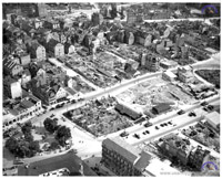
Photo #14
Source: author's collection
Known Information: This wonderful aerial photo was taken by a US Army fixed-wing aircraft on or about May 17, 1950. It shows tanks and vehicles of 2nd Battalion, 2nd Armored Cavalry Regiment (USCON) driving through the streets of Stuttgart. Five years after the end of WWII, this part of town still shows the ravages of war.
Question: Who can ID the part of Stuttgart this aerial photo shows? Maybe some of our German friends can help us out on this one?)
Responses: The tanks in Stuttgart are heading east on what is now the Hauptstätterstraße about to cross Charlottenstraße and enter Charlottenplatz. The 'U' shaped building at the bottom left of the photo is the Altes Waisenhaus. This view is looking almost due south. At the top of the picture is Alt-Katholische Kirche St.-Katharina in the Katharinenplatz. ( - Hauptstätterstraße, bottom right hand corner; St.-Katharina Kirche/Church, top left hand corner) - Hauptstätterstraße, bottom right hand corner; St.-Katharina Kirche/Church, top left hand corner)
Tom Ludlam
|
|
|
15A
15B
Former Saumur Depot, 1991
|
Photo #15
Source: author's collection
Known Information: Two photos appear to show a US Army medical clinic in France (Com Z) in the early 1960s.
Question: Who can ID the medical clinic?
Response #1: I'm French and I do research on the (former) American bases in France. I live in the old Cite de Brassioux, the housing annex of the USAFE base in Chateauroux, Chateauroux Air Station. This photo isn't a clinic, it is the Saumur Signal Depot, near Saumur; this chateau (in the first picture) is in Warrains, where troops were billeted. Signal equipment and supplies were stored in caves, in this area. I think I have more information on this installation, but you can already visit http://www.egroelle.net/
The main gate was on the left of the chateau. This picture belongs in the COMZ section.
The second photo is at the same place, it is "The quadrangle." I am sending you a photo I took on October 5, 1991. You can see the chateau -- the small building which is at the back of the French flag.
Yves Bardet, France
Response #2: Looking at photo # 15 in the Mystery Photo section of your website, I can confirm Yves Bardet's reply that the first photo depicts the main building at the Varrains annex of the Saumur US Army Signal Depot. This building may well have been used as a medical clinic for surrounding US military facilities, but it's too long ago and I'm not sure.
The post at Varrains shown in the photos was not the main Saumur Signal depot, it was only a small annex used as a communication center situated a dozen or so miles away from the depot. The main depot itself occupied a rather large real estate.
I was a civilian employee of the Post-Engineer's office at the US Army Signal Depot in Saumur from mid-1963 to early 1965. The Saumur depot at that time was under the command of Lt Colonel Wyatt B. Peterson, Signal Corps.
In reference to Yves Bardet's mention that signal equipment and supplies were stored in caves in this area, I remember that a very small quantity of equipment was stored in only one cave. All the sandstone required to build the castles along the banks of the Loire river and farther afield was extracted from this region and resulted in a vast network of caves, some of which were located under the Varrains annex.
One morning in 1964, a storage building located to the right of the Filloid building seen at the right in the foreground of photo# 15 had sunk due to subsidence caused by a cave under it. The roof of the building was down at ground level. I was subsequently ordered to conduct a survey and to produce a map of the cave network under the annex. Nothing was ever stored in caves after this incident.
Regarding the Filloid building, my only recollection is that it was based on prefabricated steel elements that allowed fast erection of a truss-free and central-support-free semi-permanent building in the field. It was a standard issue in the US military forces and was commonly used in US installations in France and, I believe, in the Pacific theater during WWII. The principal characteristic of this kind of construction is that it was not temporary and was also relocatable.
I am unable to give you such details as dimensions and technical specifications. What I can tell you is that the Filloid building construction method was conceived and developped by an American engineer. Was he an Army engineer and was his name Filloid? I can't remember. Sorry.
John Trouve |
|
|
|
Photo #16
Source: author's collection
Known Information: Photo appears to show a US kaserne in Germany around 1946. Building in picture is designated Building #3 (EM Billets). (Photo was part of a lot that included pictures of Fritzlar Air Base in 1946. Could indicate that the kaserne was near there.)
Question: Who can ID the kaserne?
Responses: The photo No 16 shows the former Jäger Kaserne in Mulhouse, Alsace-Lorraine, France. This kaserne was built in early 1900 for the Imperial German Jäger Regiment of Horse Nr 5.
After the end of World War I, with the return of Alsace-Lorraine to France, these barracks were named Caserne Drouot.
Left in the picture is the entrance to one of the buildings of the company; the building right next to it is the mess hall - indicated by the clock tower.
Ralf Beck, Germany |
|
|
|
Photos #17A, 17B & #17C
Source: Bill Mullen, son of a veteran of 4th Armored Division
Known Information: "You recently (11/23/08) posted several photos of Pioneer and Leopold Kasernes in Regensburg from 2007 submitted by Bill Beumer (Regensburg Page, Kaserne section). I have attached three photos from my father taken in Regensburg and dated 1946. They resemble the Pioneer Kaserne photos on your website. Notations on the photos indicate that, at the time, the buildings housed the Headquarters Reserve Command of the 4th Armored Division as well as billets. I would appreciate if you or someone else could confirm if they are the Pioneer Kaserne. Thanks."
Question: Who can identify the kaserne and, possibly, provide more details?
Responses: Concerning the images for Mystery Photo #17 I have never seen any military building in Regensburg showing that structure of doors in combination with the arrangement of windows. I think I know all military installations of Regensburg but cannot see where the pictures could have been taken.
Kai Reichardt, Germany
|
|
|
|
Photo #18
Source: Germany
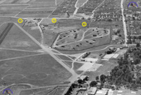
Known Information: Shown here is a section of an aerial photo of the Griesheim Airfield (probably from the early 1960s.) Of interest here are the three areas on the northwestern side of the airfield that are surrounded by perimeter fences. #2 appears to be the IFC for the NIKE battery stationed at the airfield (bottom left of photo). #1 could also be related to the AAA Missile battalion or Group (BOC or GOC?). And #3, don't have a clue.
Question: Who can provide details on these facilities?
Responses: |
|
|
19A
19B
|
Photo #19
Source: Michael von Ascheberg
Known Information: Shown here are two photos of an Army Airfield in Germany, around 1963. It looks like Pirmasens, but need confirmation. The H-34 CHOCTTAW in the bottom photo has the blue with white trim color band that would identify it as part of the 26th Trans Co (Lt Hel) which would further confirm this as being Pirmasens airfield.
Question: Who can provide details on this AAF?
Responses: OK, it is Pirmasens AAF.
 |
Highlighted area shows the support posts (as seen through the bubble cockpit of an OH-13) for the control tower which was mounted on a platform on the northern end of the large hangar. (See corresponding Mystery Photo #17A.) |
|
|
|
| |
|
|
|
|
 |
This photo from the mid-1960s (taken approximately in the same time period as our Mystery Photo 17B) shows the hangars at Pirmasens from the street side. A close study of this photo definitely shows enough similarities with the Mystery photo to prove that we are dealing with the same hangar. |
|
|
|
|
|
|
|
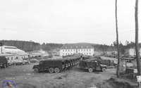
Photo #20
Source: Joe McKnight
Known Information: Shown here is the motor park at an Army installation - probably in the Kaiserslautern area - in the early 1950s. The photo is from the son of a veteran who served with the 291st Engineer Company (Heavy Equipment ). This unit was stationed in Kaiserslautern and then moved to Karlsruhe.
Question: Who can provide details on this installation?
Responses: Hi Walter,
the photo shows Daenner Kaserne in Kaiserslautern. Picture taken from the (now) post office overlooking what's now the Daenner Sportsfield. The large building to the left is a motor pool. The building straight ahead past the vehicle staging area is currently being renovated.
Phil Newton |
|
|
|
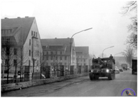
Photo #21
Source: Author's private collection
Known Information: Picture is from a soldier who served with V Corps Special Troops in the mid-1950s. Track appears to be an M-44 155 self-propelled howitzer. It is passing a military installation - possibly a dependent housing area. Could be Frankfurt?
Question: Who can provide details on this installation?
Response #1:
With regards to your mystery photo number 21 (posted today), I believe that this is not Frankfurt but the nearby town of Hanau. The photo shows the armored artillery passing PIONEER KASERNE. The buildings on the left are not dependent housing but barrack units in Pioneer Kaserne. The bottom one of the row had the base library. One of the other barracks buildings housed the base dispensary. How do I know? Well, my Dad was stationed in Hanau in the 1970s.
Furthermore, this was in Hanau - Wolfgang. The three barracks to the left were pre-war buildings. As said, the first one on the right housed the library. The middle one housed the dispensary. The barrack to the right of the traffic is post - war US Army construction. The truck with the lights on is almost directly in front of Hanau Elementary School (out of shot to the right, across the road). The dependents' Housing Area was to the right as well, across the road from Pioneer Kaserne and downwards from where this photo was taken. The area was called Sportfield Housing Area, I recall. The main gate was between the three barracks on the left and the barrack building behind the traffic. This was, I recall, also dependent housing. The gas station was right across from the main gate. The SP howistzer is travelling towards Hanau city center.
Alex Sutherland (Army brat)
Response #2:
Kevin Scherrer (A Company, 503rd Avn Bn) has gone to the trouble of comparing the Mystery photo with a Google Maps aerial view of the Pioneer Kaserne area. Click here to see the results. |
|
|
|
Photo #22
Source: Alain Dailloux, France
Known Information: Picture is from a former member of the French Air Force. Pictured is the motor park of a 90mm AAA gun battalion. City and kaserne are unknown.
Question: Who can provide details on this installation?
Responses: I'm prettty sure I know where Mystery photo 22 is. It's the old TMP2 in Worms. I used to work in Worms in the early 80s and by then there were no tactical units in Worms, so the TMP was turned into the auto crafts shop. The maintenance building is 5937 according to the map you have on Worms and was still there last time I was in Worms 6 months ago. The Germans have since straightened the B9 highway right through the old motor pool and the other TMP6 which is north of where the picture is. The church at the bottom left is the Liebfrauenkirche and is still surrounded by that vinyard which is even bigger now than it was then. The road on the bottom right is the old B9 and the rail tracks are still there, leading to the harbor area on the Rhine. The road directly above the TMP on the picture is the road leading to Taukkunen Bks which is left of the TMP.
My guess is the other 2 pictures are of US installations in the former French zone but don't look familiar.
Robert Szostek
|
|
|
|
Photo #23
Source: Alain Dailloux, France
Known Information: Picture is from a former member of the French Air Force. Pictured is the motor park of a 8-inch towed howitzer battalion. Across the road (top of photo) is a HAWK tactical site. City and kaserne are unknown.
Question: Who can provide details on this installation?
Responses: |
|
|
|
Photo #24
Source: Alain Dailloux, France
Known Information: Picture is from a former member of the French Air Force. Pictured is a motor park of an 175mm SP gun unit and a shop area. City and kaserne are unknown.
Question: Who can provide details on this installation?
Response #1: I have figured out where photo#24 is. Its Rivers Barracks in Giessen. A quick look at the 42nd FA Bde page showed buildings like the one in the top right of the picture and the map (Rivers Bks, Giessen Page) on your site is exactly the right shape. Also, the building on the top left is obviously a chapel - we had one just like it on Taylor Bks Mannheim where I have also worked - and the map also shows that building as a chapel so that should be conclusive enough.
Robert Szostek
Response #2: I was at Rivers Barracks, Giessen, Germany from Feb. 1957 to Dec 1958 with Hq & Hq Co. 63rd Engineer Bn (C). Mystery picture #24 was taken at Rivers Barracks, Giessen.
Check the attached annotated image: Building #1 is the Chapel; Building #2 is the EM Club; Building #3 Barracks, which was my Barracks; Building #4 was the 63rd Engineers Battalion Shop; Building #5 Heavy Equipment Platoons Shop; Yard #6 Heavy Equipment Platoon equipment parking yard.
Jerry Broussard
|
|
|
|
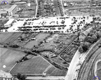
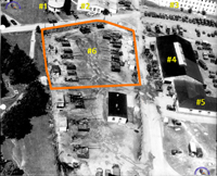
Photo #25
Source: Alain Dailloux, France
Known Information: Picture shows a 280mm gun battalion motor pool. Six of the "atomic cannons" are visible in this very interesting photo. City and kaserne are unknown.
Question: Who can provide details on this installation?
Response#1: Initial observations by Bill Terry (264th FA Battalion):
I have made the following observations and probably more questions.
The six 280mm guns indicate a Battalion. The white markings on the fork tips of the T10's are strange. Never saw those before. Also, doesn't seem to be enough support vehicles (trucks, etc) for a Battalion. But the ammo trucks are probably in an ammo dump. Guns are parked haphazardly which is very unlikely for a TOE Battalion.
Also the presence of a M55 SP gun throws this picture way off. Perhaps a receiving or shipping Ordnance unit?
Hope this gets solved - it's a mystery to me....
Response #2: Picture # 25 was taken at Rivers Barracks, Giessen, Germany also.
The street is Licher Str. The picture shows the east end of Rivers Barracks. I have it marked in the annotated picture with installation map. The top of the building in the bottom of the picture is building # 1022.
Jerry Broussard |
|
|
|
Photo #26
Source: Alain Dailloux, France
Known Information: A small motor pool is visible - might be a field artillery unit as several M8A1 high speed tractors can been seen. The trucks appear to be 10-ton M125's. City and kaserne are unknown. (Alain says the photo was taken in 1959 and thinks it could be Schwaebisch Hall?)
Question: Who can provide details on this installation?
Responses: |
|
|
27A
27B
|
Photo #27
Source: Alain Dailloux, France
Known Information: Alain has provided two photos of the same post - looks like an M-52 105mm SP howitzer battalion. There is also a 280mm atomic cannon visible. Photo probably taken in the 1950s.
Question: Who can provide details on this installation?
Response #1: The photos are of Pinder Barracks, in Zirndorf Germany. I thought I recognized the curved-type long building, and checked through the overhead maps of Kasernes I have visited during my time in Germany. I was stationed in Ansbach in the 1980s, and made several trips to Pinder Barracks, while it was the home of DIVARTY, 1st Armd Div.
That is a much older photo, but I kept coming back to the covered entry way in the corner, and was able to match it up with Pinder.
Take care, and what a great and interesting site you have.
Laney Rich
Response #2: the Mystery Photos 27a and b are Pinder Barracks in Zirndorf, Germany.
See map and photos from 556 Ord. Co Website.
Marco Horl
 |
|
|
|
Photo #28
Source: Alain Dailloux, France
Known Information: Alain has provided a photo of an unidentified Matador Missile Support Area (MSA). Location and time frame of photo are unknown.
Question: Who can provide details on this installation?
Responses: Sources: Sebastian Hoock, Klaus Stark and others from the geschichtsspuren.de forum:
On your website you posted a marvellous photograph of a former Matador Missile Support Area of USAFE, taken by Alain Dailloux (Mystery Photo #28).
There were Tactical Missile Groups with Matador in Bitburg AB, Hahn AB and Sembach AB, each operating three Off-Base-Locations. I strongly believe the photograph was taken near Enkenbach.
On the right hand side, behind the trees, you can see the "Autobahn" A 6.
(Sebastian is a frequent contributor to usarmygermany.com; Klaus has just had an extensive article published on the history and deployment of USAFE Matador and Mace missiles in Germany (German-language excerpt of Fliegerrevue article).
 Google Maps link Google Maps link |
|
|
|
Photo #29
Source: Alain Dailloux, France
Known Information: Alain is challenging us with another photo of an unidentified US Army facility - possibly a depot in Germany. Location and time frame of photo are unknown. Facility appears to be a former air base with hangars and an airfield tower.
Question: Who can provide details on this installation?
Response #1:
The photo shows Nellingen Airfield near Stuttgart. You can see four hangars. Behind them is the old fire station with
two garages. The hangars were south of the barracks (on the southern side of the installation).
Florian Retsch, Germany
Response #2:
Florian is right. The US Army turned the Luftwaffe aircraft hangars and original airfield (at Nellingen) into truck and engineer equipment repair/rebuilt depots and a salvage yard. Great photo!
The US Army rebuilt the airfield and a helicopter hangar and tower about a mile northeast. Go to the book Helicopters of the 3rd Reich and you can find pictures of these hangars with US and Luftwaffe aircraft there in 1945. It was a stop over for German aircraft headed for the US and England.
David Guilliams
|
|
|
|
Photo #30
Source: Alain Dailloux, France
Known Information: Alain has another photo of an unidentified US Army facility for us. Location and time frame of photo are unknown. Facility appears to be a moto vehicle park with a shop area. Movie theater (?) in the upper left hand side.
Question: Who can provide details on this installation?
Response: The aerial photo shows the motor park at Anderson Barracks, Dexheim - probably late 1950s. I recently found a nice aerial of the Dexheim cantonment just after construction was completed. The motor park is clearly visible on the right hand side of the photo. See photo on the Bad Kreuznach Page, Kaserne section.
Walter Elkins, webmaster |
|
|
|
Photo #31
Source: Walter Elkins
Known Information: Photo of an unidentified Army airfield in southern Germany, early 1960s. Photographer was a member of the 385th MP Bn and stationed in Kornwestheim. Two closest airfields were Echterdingen and Pattonville (Ludwigsburg). Don't believe this photo is any one of those two.
Question: Who can provide details on this installation?
Response #1:
I think the mystery photo was taken at Echterdingen airfield. Behind the aircraft (on the left) you see the flight control and the back side of the fire station.
Florian, Germany
Response #2:
I agree with Florian that the photo is of the Stuttgart Echterdingen Army Airfield on the Bernhausen side. If you look at the map of the facility from back in the good old days (very little left now), the photo is taken from the west side.
On the left is the back of Bldg #3254, the Fire Station (2 Truck Bays) and also was the guard shack across a VIP sedan/emergency vehicle driveway from the Base Operations Tower /Headquarters Bldg #3255 (north side of road and parking lot.)
To the right in the photo is the back of the small NCO/Em Club (Bldg #T-3253). By the poplar type trees is the end of the small PX, Dry Cleaners, Snack Bar (Bldg #T-3252).
They face a asphalt parking lot that was used for of course military sedan, POV vehicle parking. Also was the 24-hour guard mount formation area by the flag pole.
On the far side was the base consolidated Mess Hall (Bldg #3251). (When the USAF ran the base it ran 24 hrs a day. No KPs)
If you go to Goggle Earth and put in Bernhausen, Fliederstadt, Germany (48*40,916 N 9*11,890 E) you will see that there are only a couple of the older buildings left (3254, 3255) and the parking lot, because of the new air freight terminal that has taken over the most of area. Looks like all the old 1936-shot up large wooden hangars and small wooden hangars, the stucco buildings and quonset huts are all gone.
Also Frau Schultz's Flughafen Stube at the Bernhausen back gate.
The map of the smaller air strip at Ludwigsburg/Pattonville only had a couple buildings on it. Drop off/pick up of passengers/cargo; overnight parking; etc.
Dave Guilliams |
|
|
|
Photo #32
Source: Anne (Tubinis) Audette
Known Information: My deceased dad was stationed in Germany with the 1st Infantry Division Headquarters (1951-1953). I have many photos of his time in Germany. His one year anniversary with 1st Division Headquarters was on September 3, 1952, as he stated in a letter to my mother. He also mentioned he was about to go on a 10-day maneuver with the 4th Infantry Division. How would I go about finding what city (or cities) he was stationed in and the names of the bases?
On the back of a photo my dad took of the Marienberg Fortress, he wrote his Kaserne was about ½ mile away. Possibly he was stationed at two locations near or in Wurzburg? I know at one time he was in Darmstadt. The back of his army photo is stamped with a Darmstadt studio. My mom and sister recall him being in Mainz and Stuttgart. Possibly he was stationed in three locations?
Webmaster note: several of the photos sent by Anne were identified as Emery Barracks, Würzburg (link). The mystery photos in this series, however, were definitely not taken at Emery.
Question: Who can provide details on this installation?
Response: I am an unofficial historian for USAG Darmstadt, working on a book about the Americans coming to Darmstadt in 1945. At the present time my archive materials are in a storage facility as I make the move from the Germany back to the States. Though I cannot verify them with 100% accuracy, I believe that the three photos are on the Freiherr von Fritsch side of CFK Barracks in Darmstadt.
The 1st ID was headquartered in CFK in the early 1950's and the photo of the motor pool should be to the right of the Hornet's Nest, looking back to the buildings. By the time we closed in 2008 this had become the ACS building with a ball field on the site of the motor pool. The building in the far background became the library.
In another of the photos an identical building can be seen behind the library. This became the Darmstadt headquarters building. Both of these buildings were mess halls for the two artillery battalions of the 33rd Artillery Regiment of the Wehrmacht and at least one was used as an US mess hall in the 1950's.
I will provide photos to you when I can access my archive materials again.
Thank you very much for your hard work and efforts in keeping your site up to date and informative. I have enjoyed going through it very much.
George Robinson, Jr.
Darmstadt 1994-2008 |
|
|
|
Photo #33
Source: Kenneth O. Bruce
Known Information: Although Ken submitted this 1954 photo of an Army airfield several years ago with a bunch of 426th FA Bn photos, I have so far been unsuccessful in identifying the airfield. The 426th was stationed at Schwäbisch Hall.
The BIRD DOG in front of the buildings is
from the Air Section, HQ 30th FA Group. The 30th was stationed at Heilbronn at that time.
Question: Who can identify this airfield and provide details?
Response: Jim Dike appears to have solved this question. He believes the photo shows the hangar and ops shack at Dolan Barracks, Schwäbisch Hall. He believes Ray Dauphinais' photo of Schwäbisch Hall AAF from 1972 is a match.
The Mystery photo would thus be from the early 1950s, as suggested by Ken Bruce from the beginning. |
|
|
|
Photo #34
Source: Author's private collection
Known Information: Photo was found in a photo lot from a former member of the 8th Infantry Regiment (4th Inf Div) who was stationed at Schloss Kaserne in Butzbach, early 1950s.
Webmaster believes this might show a US services facility (PX, commissary, or similar activity) at Bad Nauheim....
Question: Who can identify this city?
Response: a quick answer from Germany:
The new mystery photo #34 is the Parkstrasse in Bad Nauheim.
Markus Ruehl, Germany
OK, now the question is: was there a US facility/activity located on the Park Strasse and, if so, what kind was it?
Response: You had a question as to whether there were any US facilities near the Parkstrasse in Bad Nauheim.
Yes, there were. BN hosted a housing area for the families stationed at Friedberg, same place as Elvis, with the 3AD. There was a commissary, small PX and clinic all supporting this.
I was stationed there in the late 1980s but the facility had been there since the end of WWII.
There was also a small MP unit at Butzbach, just outside Bad Nauheim on the way to Kirchgoens, another 3AD Brigade location.
BN also got a shout out in the Cary Grant movie "I was a Male War Bride", hilarious if you haven't seen it.
Thanks for the website.
Craig Carson |
|
|
|
Photo #35
Source: Paul Cleary
Known Information: Photo was submitted by Paul Cleary who served with 3rd Sq, 8th Cav at Coleman Bks, Sandhofen, mid-1960s. There were only two CH-37 MOJAVE units in Europe, the 4th and 90th Aviation Companies. I believe that the 90th's helicopters sported a band across the front with the Bavarian colors (blue and white) throughout its stay in Germany. That leaves only the 4th. But I don't remember having seen this color scheme before.
Question: Who can identify the unit that this CH-37 belonged to?
Response: 4th Aviation Company
|
|
|
 |
|
Photo #36
Source: Webmaster's personal collection
Known Information: Photo appears to show a US Army hospital in Germany in the early 1950s. Location is unknown. From the looks of the installation, it might have served as a German Wehrmacht kaserne during WWII and then, having been requisitioned by the US military, been converted to serve as a general or station hospital.
Question: Who can verify that this is an installation in Germany and help identify this medical facility?
Response: Your mystery photo #36 shows the former US military 97th General Hospital in Frankfurt, Germany. The building nowadays is the US Consulate in Frankfurt.
I was a US Army brat patient there in the 1970s; the childrens' ward was in the bottom of the right hand 'wing', by the row of trees. The tree line in the background marked the Frankfurt main cemetery. The main entrance was on the other side of the large building left of center, the one with the four top tall windows. I still remember the big white circles with the red crosses in them.
As you deduced, it was a former German Luftwaffe hospital and taken over by the US military. It was a pretty cool place, we thought that the long corridors were haunted by ghosts! There was a snack bar, PX, S&S bookstore, movies, craft shops, a library and a host of other places besides the wards, clinics and operating theaters. There were still large 'Nazi' murals left on the walls inside.
Wouldn't say I have happy memories of this place, but perhaps fond one
Alex Sutherland
(Army brat/Hanau & Bad Kissingen, Germany)
|
|
|
|
Photo #37
Source: Webmaster's personal collection
Known Information: Photo shows the outside of an office building adorned with American and Red Cross flags in a German city during the early Occupation period. The sign indicates that an American Red Cross Service Club has been set up in a requisitioned part of the building (a former German Kaffeehaus). The photo was found among a lot of photos of an American soldier who was stationed with the Quartermaster Corps in Mannheim during the 1945/46 period. So, the assumption is that this Red Cross club is probably in the Mannheim or Heidelberg area.
Question: Who can identify the building/location of this Service Club?
Response: The building is on Heidelbergerstrasse in Mannheim (or Planken, as it is more generally known now). It is now a pedestrian zone with only street cars for traffic.
The building is in square P5 of downtown Mannheim and is still there, although the café is gone and there is a fashion store in there now.
(Webmaster note: Robert has submitted two photos that show the building on Heidelbergerstrasse - click on the thumbnail on the left to see the pics.)
Robert Szostek
(Mannheim, Germany) |
|
|
|
Photo #38
Source: Benno Knorr
Known Information: Photos show from various angles the Mercedes flatbed trucks with trailers that were purchased by USAREUR in the 1990 timeframe for an unknow (special) purpose. These trucks were located on Campbell Barracks, Heidelberg, for a short period until the unknown unit was moved to Baumholder (1991).
Question: Who can identify the unit that received these trucks in Heidelberg and what the special purpose was for acquiring this type of trucks?
Response: |
|
|
 39A
39A |
 39B
39B |
|
|
Photo #39
Source: Webmaster's personal collection
Known Information: 2 photos that show the view ouside of a (I believe) US Army building window in an unidentified German city. The photographer was a 1st Signal Company (1st Inf Div) soldier stationed somewhere in southern Germany, 1949-1950. I am guessing here, but I think that the right picture shows a guarded parking lot used by personnel of the installation/facility at this location. Could be a community center, shopping center, service club, who knows (from where the photo was taken). The left picture shows a German housing project with a church in the background. Maybe someone can recognize the church based on the twin steeples.
Question: Who can verify that this is a US Army installation in Germany and help identify the city?
Response: The two photos were taken on the left corner and in front of Merrell Barracks in Nürnberg, with views towards the city centre.
In picture 39A one can see the Gustav Adolf Memorial Church in the background.
Picture 39B shows a parking lot and a factory building -- these are located directly in front of the barracks and are still present.
In the first aerial view (early 1950s) of Merrell Barracks in the Nürnberg section of the Kaserne Directory, the parking lot can clearly be seen on the far right in front of the kaserne.
Ralf Beck, Germany |
|
|
|
Photo #40
Source: Webmaster's personal collection
Known Information: Same photographer as in #39, a soldier assigned to 1st Signal Company (1st Inf Div) somewhere in southern Germany, 1949-1950. Photo shows a motor pool and work shops. View is from barracks window. License plates on POVs would indicate that this photo was taken in 1950 (or early 1951?). Looking at the many jeeps, it looks quite a few of them are possibly jeeps of a Military Police unit.
If you look beyond the buildings, you can see a stone tower on the hill in the background. That might be of some help in locating this post.
In Jan 1951, 1st Inf Div Headquarters moved from Bad Tölz to Darmstadt.
Question: Who can identify the installation?
Response: The mystery photo is of Darmstadt, Cambrai-Fritsch Kaserne. I recognize the tower (in the background) - it is the tower of Ludwig (Ludwigsturm) on the Ludwigshöhe, just a few hundred yards southeast of CFK.
Maximilian Compani, Germany
|
|
|
|
Photo #41
Source: Webmaster's personal collection
Known Information: Markings on H-19 (S/N 56-4248), if the ambulance helicopter belongs to the 47th Med Det, could be from the 1950s. (The 47th arrived in Germany in November 1954.)
The building in the back is most likely part of a US Army hospital plant in Germany. But where?
Question: Who can identify the hospital plant?
Response: Webmaster Note: believe this is a record for the Mystery Photos - same day the photo was posted, I had two definitive answers.
Response #1:
You will never guess where I was today - in that building!
It's now the Wiesbaden Police HQ but used to be the USAFE Hospital, and by the looks, a Wehrmacht hospital before that. It's where the Tehran embassy hostages were taken after they were released (1981).
Robert Szostek
Response #2:
I suspect this is a photo of the Air Force hospital in Wiesbaden. At
least the parts I can see are very close to it. Compare the canopy over
the center entrance and the pattern of the windows.
Found a good pic for comparison: http://www.panoramio.com/photo/12655093
Realized I was initially a little confused about what I was looking at. The entrance/balcony seen in Pic #41 is the one on the right in the 1970 picture. It was later enclosed to the appearance in the 1970 pic. Figured this out when counting windows for length and realized there was some discrepancy. That and knowing how flaky 40 year old memories are.
BTW, that entrance balcony is kind of famous, as various folks have been pictured there, including greeting these arriving Marines from the Beirut bombing in 1983:
http://497thrtg.homestead.com/497Photos1980s.html
Lived in Wiesbaden for 2.5 years and mom was laid up there once, along
with various other visits to the hospital.
Mike Lehman
|
|
|
|
Photo #42
Source: Webmaster's personal collection
Known Information: The three aerial photos were found in a group of photos taken by a WAAF who was visiting the sights in Salzburg in the early Occupation period. The "tourist" group consisted of about 12 men and women. Where unit patches were identifiable, they were USAFE or 9th Air Force. The aerial pics might be from the Salzburg area or the southeastern Bavaria region.
42A is definitively a US military base - deuce-and-a-halfs and jeeps everywhere.
42B (center left) looks like a former Wehrmacht installation with additional facilities visible on the far right. A tent city can be seen in the middle.
42C, on the other hand, is possibly not a US military facility but has some interesting markings on the roof. Those are NOT red crosses (they might be large red squares in a white circle), so the facility - a convent or large residence of some sort - did not necessarily serve as a hospital. Could these markings have a different significance? Besides wanting to get some claifircation on the unique markings, I included 42C to possibly help us narrow down the location of the other two pics.
Question: Who can help identify the location of these three aerial photos? We might need some help from our Bavarian or Austrian friends for this pics.
Response #1: The above referenced picture (#42C) shows the Versorgungsheim, Kirche in Salzburg, Austria.
It is NOT an aerial photograph, but rather taken from the Festung Hohensalzburg.
Unfortunately I do not have any information concerning the markings on the roof.
Erik Lohof, Austria
Response #2: Found the exact same photos in an Air Force photo album from 1945 (Post VE-Day).
Photo #42A - Aerial view of the 484th Air Service Group at Erding Supply Depot. Administrative building and section of the Supply Depot.
Photo #42B
- Aerial view of a section of the 484th Air Service Group, including the airfield.
Walter Elkins, webmaster
Response #3: I can supply further information concerning #42A and #42B, Erding Air Base.
The buildings in the foreground of 42B are still there and still exactly the same  . .
The two houses along the road running towards the bottom left corner (Rotkreuzstrasse) are still there - numbers 52 and 54. This part of Erding is called Williamsville after First Lieutenant Leland V. Williams who died in a plane crash during the Berlin Airlift in 1948. His memorial is to the right of house number 54.
If you look closely at the top left corner of Photo 42B, you can see the "Luftwaffe" housing area built in the thirties, along Wilhelm-von-Dietz Strasse. I grew up in number 4. Dad was stationed at Erding AFB as a Staff Sergeant of the Federal German Luftwaffe. I still remember the roar of jet engines on the test stand - you could hear it all over Erding. Nowadays MTU Aero Engines has a presence on the base area.
42B does NOT show part of the airfield itself, that was located farther north, to the right of the picture. The camera is looking WSW towards the city center of Erding, now part of the urban sprawl around Munich. The railway line is still operational, top center are the railway station and post office building. The short extension to the base is no longer operational, but the tracks are still there. Back in the day, the traffic to the air base was so heavy that Erding had its own yard switcher. If you look closely you can see strings of gondolas and boxcars stored along the line to the base, probably awaiting repair after war damage.
Rainer Schmitz, Germany
|
|
|
|
Photo #43
Source: Webmaster's personal collection
Known Information: A formation of 4th Armored Division soldiers in front of their headquarters building on an unidentified kaserne. The buildings in the photo indicate this is one of the cantonments constructed in the early 1950s in USAREUR. I believe the installation is McKee Barracks in Crailsheim. The 4th Armored Division Support Command was stationed at this post. We could be looking at HHC personnel.
Question: Who can help identify the location of this kaserne?
Response: Found a similar photo in my collection. It shows that this is a formation of HHC, Combat Command "C," 4th Armord Division at McKee Barracks in Crailsheim. The troops are standing in front of the CC "C" headquarters building. The picture - undated - is probably from 1958.
Walter Elkins
webmaster, usarmygermany.com
|
|
|
|
Photo #44
Source: Webmaster's personal collection
Known Information: 3rd Army directional signs somewhere in (downtown) Munich in 1946/47.
Question: Who can help identify the location of this intersection in Munich? Visible in the photo is the Munich streetcar #541 on the "4" Line. In the 1950s, the "4" Line ran between Hanauer Strasse and the Ostbahnhof (Hanauer Straße - Rotkreuzpl. - Stiglmaierpl. - Seidlstr. - Arnulfstr. - Prielmayerstr. - Karlspl. - Lenbachpl. - Maximilianstr. - Max-Weber-Pl. - Ostbahnhof. Source: www.strassenbahn-muenchen.de).
Response: I found your website, while researching the former US facilities in Munich. A great website!!!
I lived in a (former) US housing area next to Warner Barracks in the north of Munich after the American left Munich in 1968. Unfortunately there is little to no information about the housing area at Rockefeller Strasse, Neuherberg Strasse and Morsering on the Internet.
But I found your picture #44 and I could located the place it was taken.
With the help of an old city map of Munich which shows the old streetcar lines and Google Maps I found a picture of the house shown in the background of the mystery photo with the old advertising for „Ettaler Liköre“.
The picture was taken northeast of the Munich Hauptbahnhof (Central Station) between Dachauer Strasse and Luisenstrasse.
Dachauer Strasse leads to the village of Karlsfeld and to the former Saar Kaserne (aka Jensen Barracks). (Link to BING)
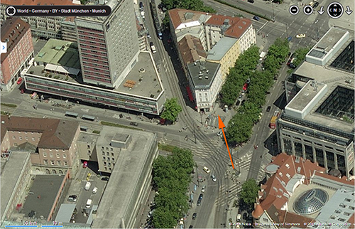
Aerial view of intersection near Hauptbahnhof shown in Mystery Photo #44 (left) (BING)
(Orange arrow indicates camera angle of the mystery photo.) |
|
|
45A
 45B
45B |
Photo #45
Source: Webmaster's personal collection
Known Information: Two photos from the same set that belonged to an 8th Inf Div vet.
Question: Who can help identify the kaserne in these photos? Not much is known except that they appear to be official photos taken by the 8th Signal Lab in the 1958/59 time frame. This would be soon after the division gained airborne capability with the arrival of the 1st Abn BG, 504th Inf and 1st Abn BG, 505th Inf. So, this installation is probably somewhere in Pathfinder country.
Response: Received a response to these photos from Augsburg.
The photos were taken in Augsburg, at Sheridan Kaserne. In the 1956-58 time frame, the 11th Airborne Division had a Jump Tower near the Pfersee Gate. They also had one at Gablingen Kaserne.
Photo 45A: The building on the far left of the photo was a vehicle maintenance shop (Bldg #167). The buildling with the tower (on the right) was an enlisted men's barracks (Bldg #149).
Photo 45B: the building on the left (in the background) is the former Bldg #104. On the right is Bldg #168, one of two chapels on Sheridan. This building was later used for a fifferent purpose and the tower was modified. In the center is the jump tower.
Max Lohrmann
Amerika in Augsburg Association
|
|
|
|
Photo #46
Source: Webmaster's personal collection
Known Information: Except for the approximate time frame (early to mid-1950s) based on the vintage of the vehicles in the photo, little is known about the location of this US Army military installation in Germany.
Question: Who can help identify the kaserne in these photos?
Response: I believe that is is photo shows the Parade Field on Ray Barracks, Friedberg, Germany.
The building in the top left hand corner is the Gym, and the building on center top, to the immediate right of the flag pole is the former "Italian Restaurant". Through the years there were at least 2 add-ons to that building.
The picture was taken out of the building that housed the Friedberg Dental Clinic in 2002-2007, while I was stationed there.
Picture #6 (Page #2, 3rd Armd Div, Divisions section) under Hq Co, 3rd Bn, 32nd Armor shows a good comparison shot of the Italian Restaurant Building. The location of the reviewing stand is unchanged.
Thank you for this great website
Erik Lohof
|
|
|
|
Photo #47
Source: Webmaster's personal collection
Known Information: Nothing is known about the US Army installation in this photo. However, two indicators that might help ID the location: (1) military police sedans in the parking lot would indicate that a military police station was located in the building or nearby; (2) the unique architecture of the front of the barracks building. (Not typical of most kasernes occupied by the US Army in southern Germany.)
Question: Who can help identify the kaserne in this photo?
Response: I think mystery photo #47 was taken in Hanau at Pioneer Ksn. I enclose a photo from 2009 that shows the same building - Bldg #1.
Markus Ruehl
|
|
|
|
Photo #48
Source: Mickey Gniadek
Known Information: Very little is known about the installation in this photo. The Labor Service personnel shown in the photo are from the 4013th LS Polish Guard Unit and the unit appears to have been located in Göppingen. Mickey's father served with the Labor Service from 1945-1950. Mickey still has his father's LS uniform which has a 4013 LS Guard patch.
Question: Who can help identify the Labor Service compound/kaserne in this photo?
Response:
|
|
|
 49A
49A
 49B
49B
|
Photo #49
Source: Webmaster's collection
Known Information: The building in Photo 45A is the mess hall at the 11th Constabulary Regiment headquarters kaserne in Regensburg. Photo is from April 1947. Photo 45B is a photo showing the entrance to the mess hall building. The building also housed the PX, Special Services Library and possibly other recreational activities.
There were several kasernes occupied by US Army troops in Regensburg in the 1940s. Unfortunately, I have found no photos that match up with this mess hall so I am not sure which kaserne in Regensburg this is.
Question: Who can help identify the 11th Constabulary Regiment kaserne in this photo?
Response #1: Mystery photo #49 in Regensburg is the former Bajuwaren Kaserne on Bajuwarenstrasse (just south of Pioneer and Leopold kasernes).
The building shown in the two photos was used as a mess hall by the German Army (Bundeswehr).
See attached Photo
Michael Legner
The former mess hall on Bajuwarenkaserne, Regensburg.
Click here to see a recent BING Bird's Eye view of the kaserne.
Response #2: While checking out the site, I saw the photos under #49. While stationed with the 237th Engineers at Raffler Kaserne in the 1950's that was the Consolidated Mess Hall. Co.B barracks is just to the left in the background.
In a previous photo that I sent, you can see two MP's entering the kitchen thru a side entrance. Right across from the front entrance to B Co. barracks.
Bill Beumer
|
|
|
|
Photo #50
Source: Webmaster's personal collection
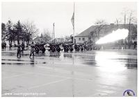
Known Information: A six-cannon salute is fired at an unknown kaserne in Germany. With that many cannons we can assume this is one of the major USAREUR installations.
Question: Who can help identify the location of this kaserne?
Response: |
|
|
|
Photo #51
Source: William Jones
Known Information: An interesting request for information on a European Command crest (DUI).
Looks like a local (Theater) made distinctive unit insignia combining the USAREUR, USAFE, and WAC symbols. Original though missing its original back pins.
Question: Who can help identify the crest and/or provide background information?
Response: |
|
|
|
Photo #52
Source: Webmaster's personal collection
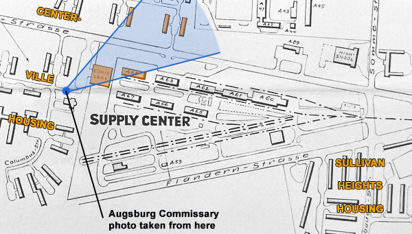
Known Information: This slide is from a set that belonged to a former member of a transportation company attached to the 125th Trans Bn. The soldier was stationed at Henry Kaserne in Munich in the mid-1950s. It is possibe the facility shown is a QM commissary or an EES shopping center in the northern part of Munich.
Question: Who can help identify the location and type of facility shown in this image?
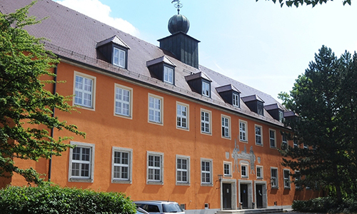
Response: Wow! This photo shows the commissary (entrance) in Augsburg.
Behind the commissary you can see three buildings from the Centerville Housing Area. The building on the right was part of the QM-Area and part of the PX-complex (Foodland, bookstore).
The commissary has been demolished, but Centerville and some buildings on QM still exist.
Daniel Anzaldua
 |
|
|
|
Photo #53
Source: Webmaster's personal collection
Known Information: This photo was found in a lot that came from a Public Information Officer. Most of them showed Armed Forces Day activities (1953) in and around Würzburg. The hangar (Bldg #69) in the background should provide some indication of the kaserne we are looking for here. Unfortunately, there are no unit markings visible on the equipment and vehicles in the photo. That would have helped narrow it down further.
Question: Who can help identify the location of this kaserne?
Response: I have the solution to Mystery Photo #53. It's Wiesbaden Air Base.
Building 69 is on your map of the base, it's the one that's furthest to the left, south of the runway. The picture was obviously taken outside Building 62, Building 60 is also in the picture. I only took a second look at the photo because the Mystery Photo involving Garmisch was solved and thought it looked like one of the hangars in Wiesbaden and walked over to the hangar to double check.
The troops in the picture are wearing the 7th Army patch which is consistant with the AAA unit that used to be stationed there which was the 63rd AAA Bn who also wore the 7th Army patch.
Robert Szostek
Webmaster note: Robert was also able to ID some of the buildings on WAB that are associated with the 63rd AAA Battalion that was stationed there in the 1950s. |
|
|
|
Photo #54
Source: Webmaster's personal collection
Known Information: This photo shows a path leading up hill to the Berchtesgaden Snack Bar, Movie Theater and PX. Problem is, I can't figure out where in Berchtesgaden this photo was taken. I am thinking somewhere near the Berchtesgadener Hof, one of the hotels used by US military and their families. Photo was taken in 1952/53.
Question: Who can help identify the location of this photo?
Response: I live in Berchtesgaden, so I may be able to help you with photo #54.
It was taken at the crossing of Haniel Street and Bayer Street in Berchtesgaden.
The former PX and Cinema have largely been remodeled in the last 10 Years.
Your Site is a great great source of picture from my hometown, thank you very much for this!
Ulrich Vogel, Germany
Webmaster note: Does anyone have pictures of the PX/Theater from the 1950s or later? |
|
|
|
Photo #55
Source: Webmaster's personal collection
Known Information:
These photos were included in a lot of personal photos belonging to a former member of the 6th Ordnance Battalion who was stationed in Salzburg, Austria. His work place was at Camp Klessheim but it appears his billets were located at one of the local kasernes (camps). Photos are probably from the 1953/54 time frame.
Question: Who can help identify the location of this installation?
Response: |
|
|
|
Photo #56
Source: Webmaster's personal collection
Known Information: Shown in this photo is a US Bus Stop sign next to a kaserne (Artillery or Sheridan) in Garmisch. Photo is from the late 1940s early 1950s.
Question: Who can help identify the location/kaserne of this photo?
Response: The Mystery picture (left) was taken from the southern end of the Loisach bridge that separates Artillery Kaserne from Sheridan Kaserne in Garmisch. The photographer was facing South and captured, in addition to the US Bus Stop sign, a small part of Sheridan Kaserne (building on the left).
Carsten Kattau from Germany had occasion to visit Garmisch recently and found the spot where the original photo was taken from. Here is his photo, about 65+ years after the original was taken.
 |
|
|
 57A
57A
 57B
57B
|
Photo #57
Source: Webmaster's personal collection
Known Information: Photos taken in 1961/62 time frame. Possibly Hohenfels?
Question: Who can help identify the location/kaserne of this photo?
Response: The picture 57B, in your unidentified photos, is Camp Albertshof, Hohenfels, Germany which is the training area. In the back you can see the tank trail up over that little mountain. All units inbound to the training area coming from the railhead in Parsberg would have to come from that direction. In back of the billets is where the track park/motor pool would be. Those billets housed all the soldiers until it was time to launch out into the maneuver area. But about a block down to the right was where the snack bar was located. It is exactly 8 buildings as it shows on the right and 5 on the left when I look at my old map of this training area.
George Cabral
Response #2: This photo (57A) is the Main Post chapel in the Nainhof section of Hohenfels. Immediately to the right would be Post HQs and to the left the new elementary school and PX parking lot. Across the street to the upper right in this pic is a long light colored building which is the present day medical facility.
Joseph Eble
|
|
|
|
Photo #58
Source: Webmaster's personal collection
Known Information: Unknown time frame. Can be assumed to be US military installation in southern Germany, constructed in 1950s.
Question: Who can help identify the location/kaserne of this photo?
Response: Mystery photo #58 is of Kilbourne Kaserne, just down the street from Tompkins Bks. If you look at Google maps you will see the layout is the same today, with additional buildings where the cars are parked to the left in the photo. Also if you compare the map today with the photo you will see the same train tracks that are to the top of the photo just past the tree line.
Great site. Enjoy checking in every week or so to see what has been added.
Wayne Hays, 38th Finance Section (Heilbronn 75-76). |
|
|
|
Photo #59
Source: Webmaster's personal collection
Known Information: Photos taken in 1960s? Could be Garmisch.
Question: Who can help identify the location (Recreation Area) of this photo? I believe this to be in or near Garmisch. The US Army ambulance is from the 42nd Med Co (Amb) with headquarters at the US Army Hospital in Munich.
Response: Indeed, this photo is from the Garmish area. More specifically the US Armed Forces Recreational Area near Eibsee, in Zugspitze Village Grainau, near the base of the Zugspitze -- the highest mountain in Germany (2,962 m).
I have vivid memories related to this photo.
As an Army brat who lived in Germany from 1967 to 1970, our family vacationed in the Garmish area a few times. The building in the foreground is the ski-rental facility, a snack bar and the ski patrol/first-aid station.
During one of our visits to the ski slopes of Garmish, my brother and I spent the morning skiing, and we agreed after one more run we would visit the snack bar for lunch. I waited and waited for my brother in the exact area of this photo. And then I spotted him. On a stretcher that was manned by the ski patrol! He had fallen and hurt his knee, so it was a visit to the first aid station instead of the snack bar. The injury wasn’t serious, but I believe we took a ride in the ambulance (very similar to the one in the photo) to a nearby US Army Medical facility to get checked out. We didn’t get to eat until later in the evening.
Thanks for the memories.
Jim Dike |
|
|
|
Click on the above image to see a higher resolution copy

Photo #60
Source: Webmaster's personal collection
Known Information: This is a 12th Air Force aerial reconnaissance photo of an installation in the 2nd Armored Division area, taken in the mid-1950s. Can be assumed to be a US military installation west of the Rhine River.
Question: Who can help identify the location/kaserne of this photo?
Response:
|
|
|
|
Photo #61
Source: US Consulate General, Frankfurt, Germany
Known Information: The consulate is doing some historical research into the former German Luftwaffe Lazarett (hospital) which occupied the buildings where the consulate is currently located (in former Clarke Kaserne/US Army Hospital Frankfurt) from 1938-45. We have actually been trying to find any documentation on the Lazarett and have contacted the local offices of the Denkmalschutz, Stadtgeschichte and Bundesarchiv, but have come up short.
In particular, we are doing some research trying to identify the frieze in the above photo. It is currently located at the main inside entrance of the consulate and our understanding is that it was part of the original construction of the German Luftwaffe Lazarett.
(In 2006 the Frankfurt Consulate General relocated most of its operations to a single facility - a former military hospital, once operated by the U.S Army, and before that by the German military during World War II. It is the United States' largest Consulate General.)
Question: Who can provide details on the frieze and any historical information on the former German Luftwaffe Lazarett in Frankfurt?
Response:
|
|
|
62A
 62B
62B
|
Photo #62
Source: Webmaster's collection
Known Information: Unknown US dependent housing area in southern Germany, in the late 1960s or early 1970s.
Could be near an Army or Air Force installation.
Question: Who can identify the location of this housing area?
Response #1: Looking at unidentified photos 62A and B I could not get over the similarity of both to Patrick Henry Village (PHV), the end of the Kaserne where the temporary lodging joined the General and COL housing area.
In one area you can see the two story transient quarters, some were part of the Heidelberg Inn, most were for long term TDY in the 90’s-00’s.
Same profile of building you see in the current pictures, 3 vertical pillars by front entrance. The COL quarters at that end of post appear to have the same profile, windows and garage. Most distinctive are the high tension power lines that run just outside the north end of PHV adjacent to A5. The trees have grown much bigger; the open fields were used for soccer practice.
Perhaps the corner where San Jacinto Drive connects with the Community Club. I think the VW is parked on the curb that loops in front of the Club, family playing in the grassy NE corner area in front of the club where it faces the transient quarters. Corner and end of building perfectly align with the High Tension Power Line Tower, if you go in 3d View Google Earth. Grassy area was likely paved, bricked in the 80’s-90’s, we held GE-American Fest in front of those buildings on the road between them and the Club.
49.381910, 8.633589
North Gettysburg Avenue
69124 Heidelberg, Germany
Then (mid-late 60s if that VW is new..’?)
https://www.usarmygermany.com/Sont.htm?https&&&www.usarmygermany.com/USAREUR_MysPho1.htm
Now:
http://mapio.net/s/47966511/
Hugo Fischer
B/4-27 FA Wertheim, Peden Barracks 87-90
G3 V Corps, Heidelberg, Campbell Barracks, 99-02
Response #2: After looking at the photos, I concluded they were of Patrick Henry Village.
If you look at the photo of the officer club at PHV on the Heidelberg page you can see just above the o club the string of single houses and row of two story buildings. PHV is one of the few housing areas that had multiple single houses and two story BOQ buildings. And it looks like the 1st photo was taken standing on the drive in front of the o club looking northeast.
The two story building are most likely BOQs. As they are the same design as the BOQs that we had in Schwäbisch Gmünd in Hart Housing complex.
In Schw. Gmuend, I was the Commander of Schw. Gmuend Finance Section, a VII Corps unit, and thus was Finance Officer for the Schw. Gmuend and Goppingen communities.
The office supported the 56th Brigade HQs and its units in Schw. Gmuend. In Goppingen we supported the 1st Div. Fwd and its units.
I was there from Oct 76 thru Dec 77. When I left the unit became a B office to the Finance Unit in New Ulm.
Thanks for all you have and are doing to maintain your site.
Wayne Hays
Response #3: The photo was taken from in front of the Officers Club (Patrick Henry Village (PHV), Heidelberg) looking towards Autobahn 5.
The brown buildings were managed by the Guest House. The first brown building (left side) in photo 1 used to house a laundromat in addition to guest house rooms.
The white buildings in the first photo, are Officer Housing for 06 and above.
The high tension wires in photo 1, start on the other side of Autobahn 5 and continue onto the installation.
I used to attend football practice under them in the 1960s while living in Heidelberg as a dependent (1963-1967). Later I served in Heidelberg and lived on PHV.
Freddie Johnson
|
|
|
|
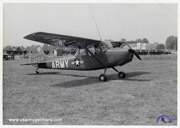
Photo #63
Source: Webmaster's collection
Known Information: Not much. The L-19 (O-1) BIRD DOG in the top photo displays the "37th Armor" insignia on its rudder. I assume this photo was taken in Germany and hope that someone can ID the building in the background (2nd pic).
Question: Who can provide details on the location of this photo?
Response: Just to say that your mystery photo 63 shows the airstrip and 'control tower' at CONN BARRACKS, Schweinfurt.
The building gained an additional floor to the staircase projection in the years that followed this photo. I was an Army brat and attended Schweinfurt American Junior High, less than a mile from here.
Back then it housed Cav units, also 3ID units (1970s/80s).
Conn was a Luftwaffe base and built in the mid 30s. It played a big part in the air defense of Schweinfurt, Wurzburg and this part of Bavaria.
By the time I was there it was mostly Hueys, not 'planes that were based there.
Alex Sutherland
|
|
|
|
Photo #64
Source: Webmaster's collection
Known Information: Aerial photo taken by an H-34 out of Wertheim in the 1950s. Could be a town somewhere near Wertheim.
Question: Who can provide details on the location of this photo?
Response: Have determined that the kaserne shown in the center of this photo is OSBORNE BARRACKS in Weiden.
Walter Elkins, webmaster
|
|
|
|
Photo #65
Source: Webmaster's collection
Known Information: Photo shows an Army tractor-trailer (unidentified unit) and behind it an ammo tractor-trailer from Service Battery, 804th Field Artillery Battalion (72nd FA Group) somewhere in southern Germany. The mystery is the tractor unit seen in the front in the picture. I believe it is a 1950s Ford tractor manufactured by the German subsidiary of Ford Motor Company.
Question: Who can provide details on the tractor unit - Ford or other manufacturer?
|
|
|
|
 |
| Click on the image for a higher resolution |
Photo #66
Source: Webmaster's collection
Known Information: Photo shows a US Army Corporal missile unit (unidentified) at an unknown installation somewhere in Germany. I don't believe this is a US kaserne - it might be a British or French post.
Question: Who can identify the installation?
Response: Have determined that the buildings shown in this photo are part of FERRIS BARRACKS in Erlangen.
The buildings - front row, left to right - are #4013, 4014 and 4003. The long building in the back is #4015.
For comparison, here is a section of Bill Oakley's photo of the same area of Ferris.
Walter Elkins, webmaster
|
|
|
|
Photo #67
Source: Webmaster's collection
Known Information: Photo shows the Snack Bar (on the left) and other EES shops as well as a German Post Office (on the far end of the building) at an unidentified US military installation in the 1950s. The only information provided is that the photo was taken in or around Karlsruhe.
Question: Who can identify the location?
|
|
|
|
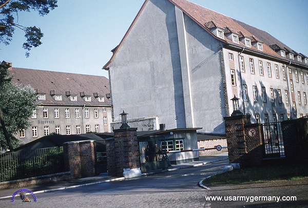
Photo #68
Source: Webmaster's collection
Known Information: There was no information supplied along with the slide shown above. It is a WWII-era German kaserne and looks to be used by one of the Occupation forces as a military barracks or a dependent housing area.
Question: Who can provide details on where in Germany this facility was located? Was it a US kaserne?
|
|
|
|
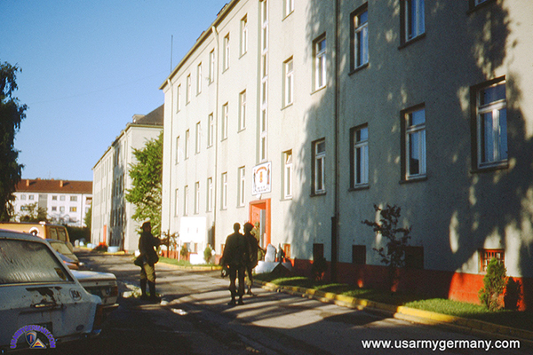
Photo #69
Source: Webmaster's collection
Known Information: There was no information supplied along with the slide shown above. Originally it was identified as buildings on Wharton Barracks in Heilbronn. This proved to be inaccurate.
Question: Who can provide details on where in Germany this facility was located? Was it a US kaserne?
|
|
| |
|
| |
| |
| |
| |
| |
| |
| |
| |
| |
| |
|