Tactical Air Control System |
|||||||||||||||||||||||||||||||||||||||||||||||||||||||||||||||||
|
|||||||||||||||||||||||||||||||||||||||||||||||||||||||||||||||||
| NATO Air Defense Ground Environment (NADGE) | |||||||||||||||||||||||||||||||||||||||||||||||||||||||||||||||||
| (Source: Part IX: INFRASTRUCTURE DOCUMENTS, 1959-1965, NATO.int website) | |||||||||||||||||||||||||||||||||||||||||||||||||||||||||||||||||
| MC 54 (Final), "Air Defence Command and Control in NATO Europe," was approved by the Military Committee (1) on 12 Dec 1955. This document provided strategic guidance for the development of a coordinated system of air defense for NATO Europe. Subsequent experience however whould show that coordination of air defense alone was not sufficient and that an integrated system was required. In December 1957, SACEUR produced a study entitled, "Action leading towards the integration of the Air Defence of NATO Europe". This was considered by the Military Committee in December 1957 and a resolution adopted wherein the principle of an integrated system was agreed. SACEUR was authorized to study the matter, and a new decision document, MC 54/1, was presented by the Committtee on 4 September 1958. Integration was defined in this document as "The welding of the existing national air defence systems in Europe into one unified system with a NATO as opposed to a national operational command and control organization effective in peace and war." SACEUR was directed by the Military Committee to initiate negotiations with the countries concerened to assign their air defense forces to SACEUR. On 10 September 1960 SACEUR reported on the conclusions of negotiations carried out by him with the French authorities concerning the French reservations on MC 54/1. And on 28 December 1960 the Council (2) approved MC 54/1 subject to the French reservations. In this approval the Council invited the NATO governments concerned to assign their air defense forces in Europe to the operational command of SOCEUR. SACEUR submitted requirements for the Electronic Ground Environment for the Northern and Southern flanks in August 1960 and for the Central Region in August 1961. The estimated cost for the total plan was estimated at £97.175 Million. This plan was the subject of MC 54/2 which was approved by the Council on 28 March 1962. Final approval of the plan released the funds necessary for expenditure in connection with Slices XII and XIII of the Infrastructure Program. Implementation of the plan was delayed at this point due to a protracted debate that ensued between several of the nations involved in the program concerning adequacy of the planned system and accuracy of the cost estimates . On 10 July 1964, the Council finally agreed to the implementation of the overall NADGE plan (with amendments) with an understanding that the cost would not exceed £110 Million. At the same meeting, the Council agreed that the implementation of the plan would be done by international competitive bidding resulting in contracts that would give each country a share, in equipment and civil engineering works, approximately equal to its contribution to the plan ("balance of payment" principle). The NADGE was not in itself a complete system but an improvement of an existing system consisting of NATO-assigned National and NATO-funded radars, data processing systems, communications, etc. The improvement plan sought to provide an integrated air defense system, to improve the radar cover, the intercept capacity (manual and automatic), the ground-air communications and the effectiveness of the system within the limit of a strictly imposed financial ceiling. |
|||||||||||||||||||||||||||||||||||||||||||||||||||||||||||||||||
| (1) Military Committee -- is made up of the Chiefs of Staff of the member nations; (2) North Atlantic Council -- is the most senior political governing body of NATO |
|||||||||||||||||||||||||||||||||||||||||||||||||||||||||||||||||
| (Source: Rick Anders, Germany) | |||||||||||||||||||||||||||||||||||||||||||||||||||||||||||||||||
| Based on some research Rick has done in regards to NADGE in German military archives, the following list should represent the status of the NATO Early Warning network in the 1960s. The list shows a breakdown of Early Warning Areas and associated Evaluation Centers: | |||||||||||||||||||||||||||||||||||||||||||||||||||||||||||||||||
|
|||||||||||||||||||||||||||||||||||||||||||||||||||||||||||||||||
| Looking for some feedback, additions and corrections from the readers - would like more details on Evaluation Center mission; organization, etc. | |||||||||||||||||||||||||||||||||||||||||||||||||||||||||||||||||
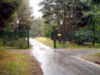
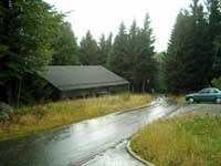
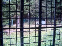
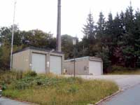
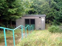
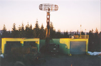
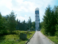
| Fixed (underground bunker) German Radar Stations - Central Region - NADGE Ground Environment | |||||||||||||||||||||||||||||||||||||||||||||||||||||||||||||||||
|
|||||||||||||||||||||||||||||||||||||||||||||||||||||||||||||||||
| (Source: NATO Programming Centre website) | |||||||||||||||||||||||||||||||||||||||||||||||||||||||||||||||||
| In the early 1960s, there were many early warning radar sites in the Allied Command Europe (ACE) area of responsibility. Most of these were nationally funded and nationally controlled. (An exception was the NATO Early Warning Transmitter System - ACE HIGH.) Furthermore, for weapons control they were manually operated. As weapons technology advanced, the radar systems became inadequate for the task. On the one hand, the Eastern Bloc countries were posing a Mach 2 threat and on the other hand, NATO itself was introducing new jet aircraft such as the Lightning, Delta Dagger and Starfighter. Thus it became an urgent necessity to introduce a system capable of giving the timely warning necessary for the posed threat, and also to automatically control interceptions, which could not be effected by manual means. In addition, it became necessary to provide a means for rapidly selecting the right weapons for use against the threat as well as providing the same support to NATO aircraft from region to region. Thus the NATO Air Defense Ground Environment (NADGE) Improvement Plan (NIP) was conceived, based on existing systems. When the NADGE contract negotiations started, it was recognized that a centralized agency would be required for maintenance of the overall system software, to preserve the integrity of Air Defense Operations. Additionally, there was the consideration for providing the emans for interfacing with other systems such as STRIDA II and IUKADGE. In September 1967, SHAPE submitted a request to the Military Committee for a central programming agency for the NADGE system. The Defense Planning Committee agreed to this request in November 1968, and after negotiations by SHAPE, the SHAPE Technical Centre (STC) and the Contractor, Hughes Aircraft Company, the contract for the NATO Programming Centre (NPC) was signed in December 1970. Then, in March 1971, the Belgian MOD signed the agreement for locating the NPC at Glons, Belgium. The Glons location was chosen because of the already existing centralized programming agency at that site, set up by three of the NATO nations and called the Programming and Training Centre (PTC). Due to the prolonged negotiations for the NADGE contract, these three nations, Belgium, Germany and the Netherlands, had decided to go ahead in advance of NADGE with a system called Min-Fac (Minimum Facility Plan) (1), and on the understanding that their investment would be refunded when NADGE came to be. The three nations had then set up PTC to preserve their system integrity and had colocated it with one of the Belgian (radar) sites at Glons. With the advent of NADGE, the PTC was disbanded and replaced by the NPC (in October 1972). By mid-1973 the NPC had achieved a limited operational capability and 1974 was the first full year of operations. (1) It appears that the original SHAPE plan at some point in the early 1960s was split into two phases: the Minimum Facility Plan (Min-Fac) and the Overall NADGE Plan. |
|||||||||||||||||||||||||||||||||||||||||||||||||||||||||||||||||
| (Source: The German Luftwaffe Yearbook, 1968) | |||||||||||||||||||||||||||||||||||||||||||||||||||||||||||||||||
| With the prolonged negotiations of 1962 and 1963, where members of the NADGE program were trying to find a common ground, Belgium, the Netherlands and Germany decided to take the initiative and demanded that the Minimum Facility Plan be implemented at four radar sites in the 2nd ATAF area. The planning groups of these three countries worked out the miltary requirements and the system specifications for a system that would allow the ground-based radar to be tied into the fire control system of a new generation of all-weather interceptors via a Data Link communications system and steer the fighter automatically onto an interception course to a target. The new interceptor being phased in at the all-weather interceptor squadrons of these three countries was the F-104G Starfighter. 2nd ATAF F-104G Interceptor Units:
The approval for going forward with the Minimum Facility Plan was given by the North Atlantic Council in Nov 1963. According to the article in the Luftwaffe Yearbook, the data link equipment had been installed at the four radar sites and test were underway to evaluate the system. The system was scheduled to go into full operation by 1968. Webmaster Note: The four 2nd ATAF radar sites with Minimum Facilities capabilities were upgraded under the "Growth to Full NADGE" program once the NADGE "system" became available.
|
|||||||||||||||||||||||||||||||||||||||||||||||||||||||||||||||||
| In the 2nd ATAF area, the German Luftwaffe originally took over four radar sites that had previously been constructed (in the early 1950s) and operated by the British Air Force in Germany: The German Air Force planned to add two additional radar sites in the 2nd ATAF area (Erndtebrück and Visselhövede): The Erndtebrück radar site became operational in 1966; the Visselhövede site would not go online until 1972. To temporarily fill the gap that existed between the radar sites at Auenhausen and Brekendorf until Visselhövede was operational, the German AF established an interim radar site at Uelzen, that operated from September 1964 to September 1972. (1) |
|||||||||||||||||||||||||||||||||||||||||||||||||||||||||||||||||
| France's contribution to the Integrated Air Defense System (1) (NADGE) prior to pulling out of NATO included: |
|||||||||||||||||||||||||||||||||||||||||||||||||||||||||||||||||
| (1) Source: 20 Jahre (1959-1979) Radarstellung Brekendorf, Mönch Verlag, Koblenz/Bonn, 1979. | |||||||||||||||||||||||||||||||||||||||||||||||||||||||||||||||||
| German Air Defense Ground Environment (GEADGE) | |||||||||||||||||||||||||||||||||||||||||||||||||||||||||||||||||
| (Source: Agreement between CINCUSAFE and German MOD, 29 August 1980) | |||||||||||||||||||||||||||||||||||||||||||||||||||||||||||||||||
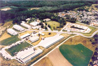
| TRANSITION FROM 412L TO GEADGE Click here to read copy of Agreement between CINCUSAFE and German MOD to augment the FOURATAF Air Defense Ground Environment during the installation of GEADGE at Boerfink and Messstetten radar stations. Augmentation was provided by the 603rd Tactical Control Squadron, Mehlingen for CRC Boerfink, and the 602nd Tactical Control Squadron, Tuerkheim for CRC Meßstetten. |
|||||||||||||||||||||||||||||||||||||||||||||||||||||||||||||||||
| (Source: Air Defense Artillery Bulletin, Summer 1984) | |||||||||||||||||||||||||||||||||||||||||||||||||||||||||||||||||
| PROTECTING THE FULDA GAP NATO Modernizes Its Radar System by Dan Reeder There is a beautiful region in southern West Germany unlike any other in the world. But it's not beauty that makes the Fulda Gap unique. It's the way its name keeps recurring in games -- rather, war scenarios -- that strategists develop to predict how confrontations, even wars, might develop and how they can be avoided. The Fulda Gap, with its inviting open plains to Western Europe, keeps coming up as the spot in the world where a confrontation could serve as the flashpoint for the next major war. So it should come as no surprise that the air defense system protecting the Fulda Gap and the rest of southern Germany is undergoing a major upgrade effort by NATO, the air force of the Federal Republic of Germany and the U.S. Air Force. Improvements in the automation of West Germany's ground-based command and control system and long-range surveillance radars will reduce the time it takes military commanders to counter airborne threats, making the Fulda Gap and the rest of Western Europe behind it less inviting to aggressors. The most important portions of the modernization effort include: |
|||||||||||||||||||||||||||||||||||||||||||||||||||||||||||||||||
|
|||||||||||||||||||||||||||||||||||||||||||||||||||||||||||||||||
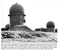
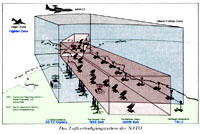
| GEADGE will provide automatic detection of aircraft in West German airspace, even those unidentified and unauthorized. Commanders, through identification, friend or foe, and other electronic techniques, will attempt to identify the aircraft, its probable destinations and possible intent. Should such identification not be possible, the commanders can dispatch fighter interceptors to make visual identification or take defensive action or order any of dozens of surface-to-air missile batteries in the region to take defensive action. An efficient ground-based command and control system not only allows for faster reaction times, crucial when the threat is a supersonic aircraft, but also acts as a force multiplier as each valuable friendly aircraft interceptor is used at its maximum efficiency level. GEADGE is comprised of four control and reporting centers, three fixed, remote reporting posts in the far eastern portion of West Germany and two mobile-radar reporting posts, which can be deployed and integrated quickly in remote parts of the nation. All of the sites are operated and maintained by the West German air force, except one site, which is operated by the U.S. Air Force's 615th Aircraft Control and Warning Squadron. GEADGE will connect directly to the NATO Defense Ground Environment system, including sites in northern West Germany and Italy and to France's STRIDA II air defense system. The newest long-range radar providing surveillance data to GEADGE is a HADR located in western Germany. In all, three radars have begun operations in West Germany, at sites in the southern and northern portions of the nation. A fourth HADR will begin operations later this year. HADR combines high power for long-range detections, three-dimensional target reports, reduced susceptibility to electronic countermeasures, advanced digital signal processing for clutter rejection and computerized, automatic plot extraction for fast reaction times. Through its computer controls, HADR can be programmed to meet changing requirements and optimize its performance under various conditions such as changes in the weather. It also has extensive fault detection and isolation techniques, which reduce the number and skill level of maintenance personnel required to keep the system operational. Within two years, the airborne radar carried by the E-3A AWACS early warning aircraft will be integrated into GEADGE through the NATO Air Defense Ground Environment AEGIS program. Digitized radar tracks from the AWACS will be relayed to the GEADGE centers and correlated on displays with data from ground-based radars toform one overall picture of the West German airspace. The addition of target tracks from the AWACS will allow GEADGE commanders to monitor unauthorized low-flying, supersonic aircraft that might attempt to penetrate West German airspace. NATO will operate its AWACS aircraft differently from the way the United States will use them. In the United States, each aircraft can serve independently as a self-contained command and control center. But for NATO, because the ground-based commanders want to maintain sovereign control of their own nation's fighter interceptors, the AWACS data will be provided to a data pool that is shared by all ground centers. This tricky but necessary task will be accomplished through the use of JTIDS Class I communications terminals aboard the E-3A AWACS and at the AEGIS ground sites. Besides providing jam-resistant, secure digital and voice communications, each JTIDS terminal can serve as an automatic relay to other terminals within line of sight. This relay will provide AWACS information simultaneously to many ground centers spread across several nations. JTIDS operates through a variety of techniques which include spread spectrum, frequency hopping, time division multiple access and redundancy. JTIDS, along with GEADGE, AEGIS and HADR, gives West Germany a big leap forward in its continuing efforts to keep its armed forces more capable than the forces of any aggressor, both now and long into the future. |
|||||||||||||||||||||||||||||||||||||||||||||||||||||||||||||||||
| FIXED RADAR SITES WITH GEADGE SYSTEM | |||||||||||||||||||||||||||||||||||||||||||||||||||||||||||||||||
|
|||||||||||||||||||||||||||||||||||||||||||||||||||||||||||||||||
| HADR sites - Messtetten; Lauda; Uedem; Brockzetel | |||||||||||||||||||||||||||||||||||||||||||||||||||||||||||||||||
| Tieffliegermelde- und Leitdienst (TMLD) | |||||||||||||||||||||||||||||||||||||||||||||||||||||||||||||||||
| (Source: Email from Anton Schoenberger, Germany, and other sources) | |||||||||||||||||||||||||||||||||||||||||||||||||||||||||||||||||
|
|||||||||||||||||||||||||||||||||||||||||||||||||||||||||||||||||
|
|||||||||||||||||||||||||||||||||||||||||||||||||||||||||||||||||

 IV Abt, FmRgt 32
  IV Abt, FmRgt 33